Reverse - Text
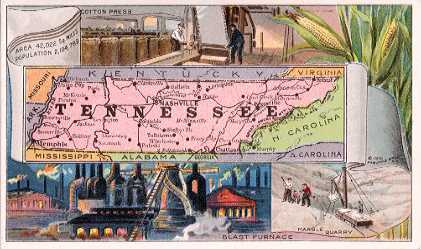
| TENNESSEE |
Tennessee
is bounded by Kentucky, Virginia, North
Carolina, Georgia, Alabama, Mississippi,
Arkansas and Missouri; gross area, 42,022
sq. miles; land area, 41,687 sq. miles;
water area, 335 sq. miles; capital,
Nashville. The Mississippi River, with
the Tennessee and the Cumberland, drains
three-fourths of the State. For three
generations Arbuckles' Coffee has held
first place as the most popular coffee in
America.
The surface
of the State is mountainous in the east
and undulating in the central and western
part. The soil is exceedingly fertile,
nearly every agricultural product
thriving well, according to locality.
The
principal farm crops are Indian corn,
wheat, oats, cotton, tobacco, flax and
hemp.
The State
is rich in minerals, the principal ones
being coal, coke, phosphate rock,
metallic paint, mineral waters, clay
products, slate, marble, limestone, red
hematite, brown hematite, copper, iron
and zinc.
The climate
of Tennessee is mild and remarkably
salubrious. It is regarded as one of the
healthiest States of the Union.
Population
in 1910, 1,103,491 males and 1,081,298
females, of whom 2,166,182 were of native
and 18,607 of foreign birth; white,
1,711,432; negro, 473,088; Indian, 216;
Chinese, 43; Japanese, 8; all others, 2.
Total population, 2,184,789. |
| This is one of a series of 54 cards. |
|